
One of my absolute favorite things to do when I am out riding around is to find roadside oddities and attractions. I have been known to make many a U-turn while driving down the road. This page will be dedicated to any roadside attractions that I have found in the state of Arizona.
It will be a constant work in progress as I will add new oddities and attractions every time I find one. Make sure you check back often for new updates. Better yet, subscribe to my site so you will be informed each time content is added. Don’t worry, no spam here. I only send out emails once a week, usually on Fridays. Subscribe Here
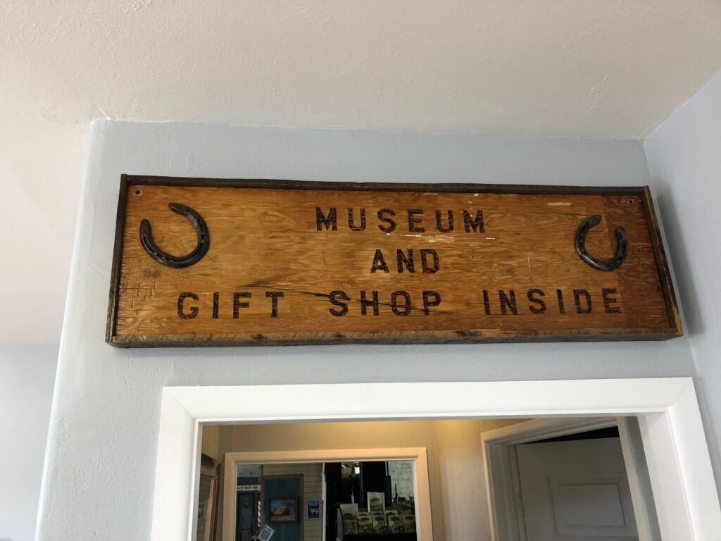
Ash Fork Museum
Location: 901 Old Rt 66
City: Ash Fork
Region of State Located: West Central
Google Maps Pin
Located in the “Flagstone Capital of the World,” the Ash Fork Museum is a must-stop for Route 66 enthusiasts. Housed in an old escalante-style building that once served as a company store for the railroad, this museum is a treasure trove of local history, railway lore, and pioneer spirit.
It’s a community-run gem that captures the transition of Ash Fork from a major railroad hub to a quintessential Route 66 town.
Outdoor Exhibits: Don’t miss the outdoor machinery and historical equipment that give you a sense of the heavy lifting required to settle this rugged part of Arizona.
The Flagstone Connection: You’ll see fascinating displays on the local stone industry that built much of the surrounding region, including the unique techniques used to quarry the famous Arizona sandstone.
Railway & Route 66 Heritage: The museum features extensive memorabilia from the Santa Fe Railroad and the “Mother Road,” including vintage signs, photographs, and artifacts from the Harvey House era.
The “Old West” Vibe: Beyond the industrial history, there are displays dedicated to the local ranching families and life in the high desert during the early 20th century.
Big Diamond
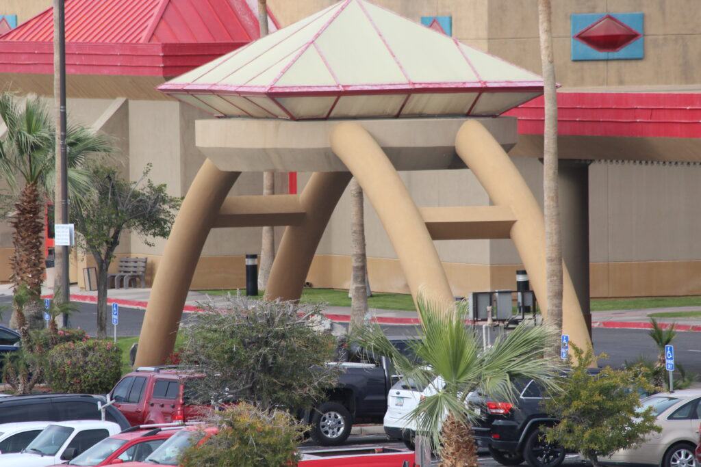
Location: 450 Quechan Dr (Outside The Paradise Casino)
City: Yuma
Region of State Located: Southwest Corner
Google Maps Pin
Located right on the California-Arizona border, The Big Diamond is a glittering, oversized roadside gem that marks the entrance to the Paradise Casino on the Quechan Indian Reservation.
While it’s not a “natural” wonder like the Grand Canyon, this massive, multi-faceted sculpture has become a favorite navigation point and photo op for travelers heading into Yuma or crossing the Colorado River.
Photography Tip: Because of its reflective surface, it’s a tricky but rewarding spot for photographers to try to catch it during the “Golden Hour” for the best desert reflections.
High-Shine Landmark: The sculpture is designed to mimic a classic brilliant-cut diamond, standing several feet tall and catching the intense Arizona sun from every angle.
Nighttime Glow: After the sun sets over the desert, the diamond is often illuminated with colorful LED lights, making it even more of a standout feature against the dark Yuma sky.
The “Gateway” to Fun: Its location is strategic; it’s positioned to welcome visitors to the casino and the nearby tribal lands, serving as a bright symbol of the “paradise” promised by the venue’s name.
Bridge To Nowhere (Mcphaul Bridge)
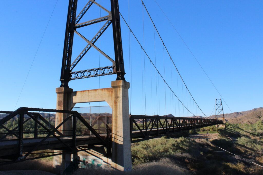
Location: US Highway 95, 4.5 miles north of Fortuna Rd
City: Yuma
Region of State Located: Southwest Corner
Google Maps Pin
Deep in the desert sands north of Yuma stands one of Arizona’s most haunting and photogenic structural “oddities.” The McPhaul Bridge, widely known as the Bridge to Nowhere, is a massive suspension bridge that spans… absolutely nothing.
Built in 1929 to carry Highway 95 over the Gila River, the bridge was rendered obsolete when the river was diverted following a massive flood and the construction of the Dome Valley dikes. Today, the riverbed is bone-dry desert, and the highway has long since been moved to a modern crossing nearby.
Cinematic Vibe: Its rusted cables and sun-bleached wood planks give it a post-apocalyptic look that has made it a legendary spot for desert photography and local folklore.
A “Ghost” Bridge: The bridge is a rare example of a 1920s suspension design in the Southwest. It looks completely out of place standing over shrubs and sand instead of rushing water.
The Diversion: In 1968, the Gila River was rerouted, leaving this 800-foot-long structure stranded in the middle of the desert.
Safety Warning: While it is a magnet for urban explorers and photographers, the bridge is structurally unsound and officially closed to pedestrians and vehicles. It’s best admired and photographed from the safety of the roadside.
Note: You can take a dirt road off to the side and drive under the bridge which was pretty cool.
Castle Dome Mine Museum

Location: Castle Dome Mine Rd
City: Yuma
Region of State Located: Southwest Corner
Google Maps Pin
Castle Dome City & Museum is arguably the most immersive “ghost town” experience in the Southwest. Unlike many replicas, this is a meticulously preserved time capsule sitting on the site of the longest-running mining district in Arizona history.
Walking into Castle Dome isn’t just a museum visit, it’s like stepping through a portal into the 1870s.
Sun-Bleached Authenticity: The location at the base of the distinctive Castle Dome Peak adds a dramatic, rugged backdrop that makes it a dream for photographers and history buffs alike.
A “Living” Ghost Town: While many towns were salvaged or burned, Castle Dome was tucked away on a military range for decades, which helped preserve the original structures. It features over 50 weather-beaten buildings, including a saloon, a church, and a sheriff’s office.
The “Hull” Mine: One of the most unique aspects is the underground museum. It features the “Fluorescent Wall,” where the mine walls glow with vibrant, otherworldly colors under UV light due to the natural minerals in the rock.
Artifact Overload: The sheer volume of period-correct artifacts is staggering. You’ll find everything from 150-year-old Levi’s jeans found in the shafts to original canned goods still sitting on the shelves of the general store.
General Store
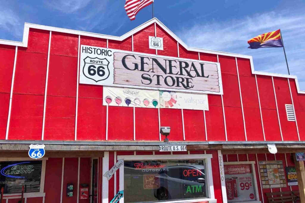
Location: 22940 Historic Rte 66,
City: Seligman
Region of State Located: North/West
Google Maps Pin
The Historic Route 66 General Store in Seligman is a quintessential stop on the “Mother Road,” serving as both a practical supply point and a nostalgic journey into the past. Seligman itself is often credited as the birthplace of the historic Route 66 revival, and this store captures that spirit perfectly with its rustic charm and desert-town hospitality.
- Authentic Roadside Vibe: The store maintains the feel of a classic mid-century trading post, filled with a mix of essential groceries and an extensive collection of Route 66 memorabilia.
- Convenience for Travelers: It is one of the few reliable spots in the area to grab snacks, cold drinks, or supplies before heading out on the long, scenic stretches of highway.
- Local Landmark: Its location on the historic loop makes it a popular photo op for those exploring the town’s vibrant, neon-lit storefronts and vintage cars.
There are a lot of cool things inside such as talking statues. It’s a fun stop!!!
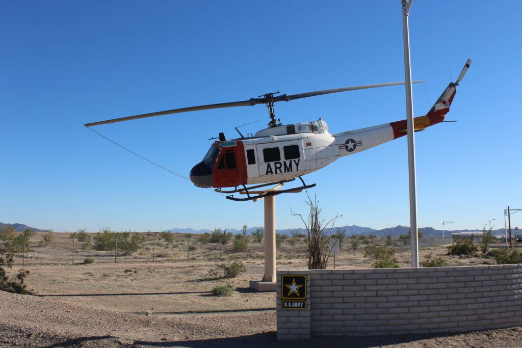
Helicopter On A Stick
Location: Yuma Proving Grounds
City: Yuma
Region of State Located: Southwest Corner
Google Maps Pin
Perched atop a tall pedestal near the Howard entrance (on the southwest side of the installation), this Bell UH-1 “Huey” helicopter serves as a gate guardian, greeting personnel and visitors with a silent salute.
The Huey is arguably the most iconic helicopter in American military history, and its presence here highlights the critical role Yuma plays in testing the aircraft that our troops rely on.
A “Closed” Landmark: Because it sits at the entrance of a secure military installation, it’s a “look-but-don’t-touch” attraction. It’s best viewed from your vehicle as you pass the gate area.
The “Workhorse” of Vietnam: The UH-1 Huey became the symbol of US Army aviation during the Vietnam War, used for everything from troop transport and medevac to air assaults.
YPG’s Testing Legacy: This helicopter isn’t just for show; it represents decades of rigorous testing conducted at the Proving Ground. Almost every piece of equipment used by Army Aviation, from the airframes themselves to the weapon systems and parachutes, has been put through its paces in the Yuma desert.
Static Display: Mounted in a slight “banking” turn, the display gives the illusion of flight, making it a favorite landmark for those traveling along the outskirts of the military reservation.
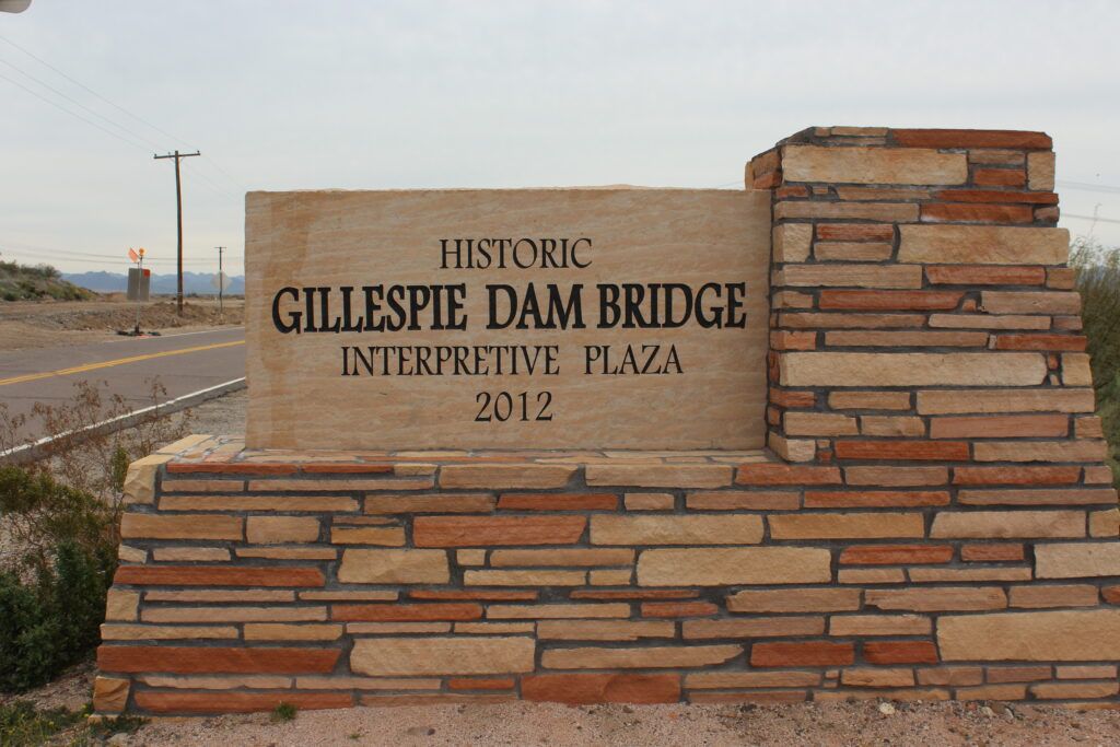
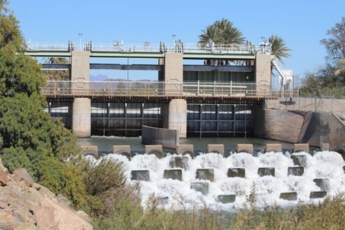
Historic Gillespie Dam & Bridge
Location: S. Old US Highway 80
City: Arlington
Region of State Located: Southwest
Google Maps Pin
Located between the towns of Buckeye and Gila Bend, the Gillespie Dam Bridge is a majestic piece of Arizona’s engineering history. This massive, multi-span steel truss bridge was completed in 1927 and served as a vital link on the original Old US Highway 80, which was once known as the “Broadway of America.”
While the bridge still stands as a testament to early 20th-century craftsmanship, it now overlooks the ruins of the dam that shared its name.
The “Broadway” Heritage: Driving across this bridge is like traveling back in time to the golden age of cross-country road trips, before the interstates bypassed these scenic desert routes.
The Great Flood of 1993: The most dramatic part of this site’s history occurred in 1993 when unusually heavy rains caused the Gila River to swell. The pressure became too much, and a massive 120-foot section of the Gillespie Dam collapsed. You can still see the jagged remnants of the dam in the riverbed today.
Architectural Grandeur: The bridge features nine steel spans and stretches over 1,600 feet. Its intricate “tinker-toy” steel lattice makes it one of the most photographed bridges in the state, especially against a desert sunset.
An Oasis for Wildlife: Because the remaining portion of the dam still creates a small pool of water, the area has become an unexpected wetland in the middle of the desert, attracting a wide variety of migratory birds and waterfowl.
Laguna Dam
Location: Laguna Dam Rd
City: Yuma
Region of State Located: Southwest
Google Pin
Located on the Colorado River, the Laguna Dam is a true pioneer of the desert. Completed in 1909, it holds the title of the first dam ever built on the Colorado River, predating the world-famous Hoover Dam by over 25 years.
It’s an incredible example of early 20th-century engineering that literally paved the way for the agricultural boom in the Yuma Valley.
Birdwatcher’s Paradise: Because the dam creates a steady pool of water and marshland, the surrounding area has become a lush habitat for herons, egrets, and other desert wildlife, making it a peaceful contrast to the rugged Yuma landscape.
The “Indestructible” Design: Unlike the towering concrete arches we see today, Laguna is a “weir” or “rock-fill” dam. It was designed to allow water to flow over it, using a massive concrete-topped rock structure that was revolutionary for its time.
Taming the “Red Bull”: Before this dam was built, the Colorado River was notoriously wild and unpredictable (earning the nickname “The Red Bull”). Laguna Dam was the first successful attempt to divert those waters for irrigation, turning the arid desert into fertile farmland.
A “Working” Landmark: Even though it’s over a century old, the dam is still a functional part of the region’s water management system, serving as a regulating structure for the water flowing toward the Imperial Dam downstream.
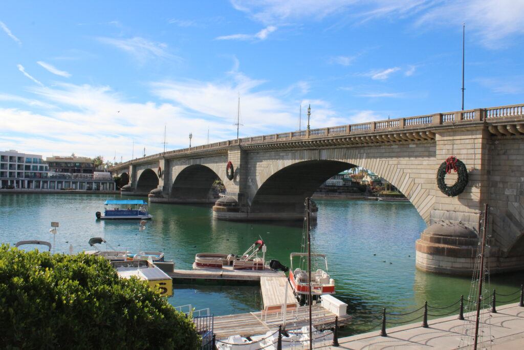
London Bridge
Location: 1340 McCulloch Blvd N
City: Lake Havasu
Region of State Located: West Central
Google Maps Pin
Lake Havasu City is a piece of genuine British history transported to the Arizona desert. This is the actual 1831 bridge that once spanned the River Thames in London; it was purchased by Robert McCulloch in 1968, meticulously dismantled block by block, and shipped across the ocean.
It’s an architectural marvel that completely transformed Lake Havasu from a remote landing into a major tourist destination.
The “Mistake” Myth: A popular local legend claims that McCulloch bought it thinking he was getting the more ornate Tower Bridge, but he always maintained he knew exactly which bridge he was buying!
Dismantled and Rebuilt: Every one of the bridge’s granite blocks was numbered before being shipped through the Panama Canal. It was then reassembled in Arizona over a reinforced concrete structure, a process that took three years to complete.
English Village: The bridge serves as the centerpiece for the English Village, a themed open-air mall designed to look like a traditional British town, complete with shops and eateries.
Wartime History: If you look closely at the granite, you can still see pockmarks and scars from strafing fire during the London Blitz in World War II.
Oatman
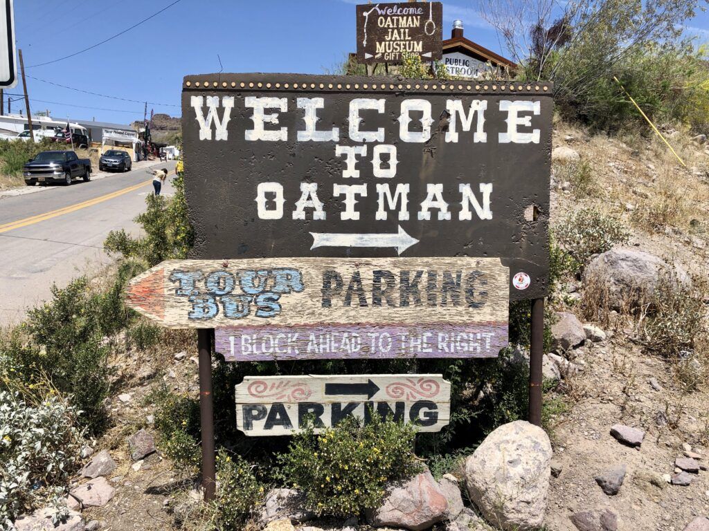
Location: Black Mountains of Mohave County
City: Oatman
Region of State Located: West Central
Google Maps Pin
Oatman is a living ghost town that feels like a movie set come to life, perched high in the rugged Black Mountains along a particularly scenic (and white-knuckle) stretch of Route 66. It is one of Arizona’s most unique stops because it has completely embraced its eccentric history and its four-legged residents.
The town is famous for the wild burros that wander the streets daily, looking for treats and outnumbering the human population.
Oatman Hotel: This historic landmark is famous for its “dollar bill” walls, thousands of signed bills pinned up by travelers, and the legend that Clark Gable and Carole Lombard spent their honeymoon there.
The Wild Burros: These “hilarious” residents are descendants of pack animals used by gold miners in the early 1900s. They are friendly but persistent, often blocking traffic or peeking into shop doors in search of “burro chow” sold by local vendors.
Sitgreaves Pass: The drive to get there is an attraction itself. The road from Kingman to Oatman winds through hair-pin turns and steep drop-offs, offering some of the most dramatic desert vistas in the state.
Historic Gunfights: You can catch daily wild west shootouts staged right in the middle of the main street, complete with period costumes and plenty of comedy.
Music in the Video: Dreamy, Soaring, Wonder- Marrakakech to Bombay (Inst) by Color Palette
Licensed Through Canva Pro
Pivot Point Plaza
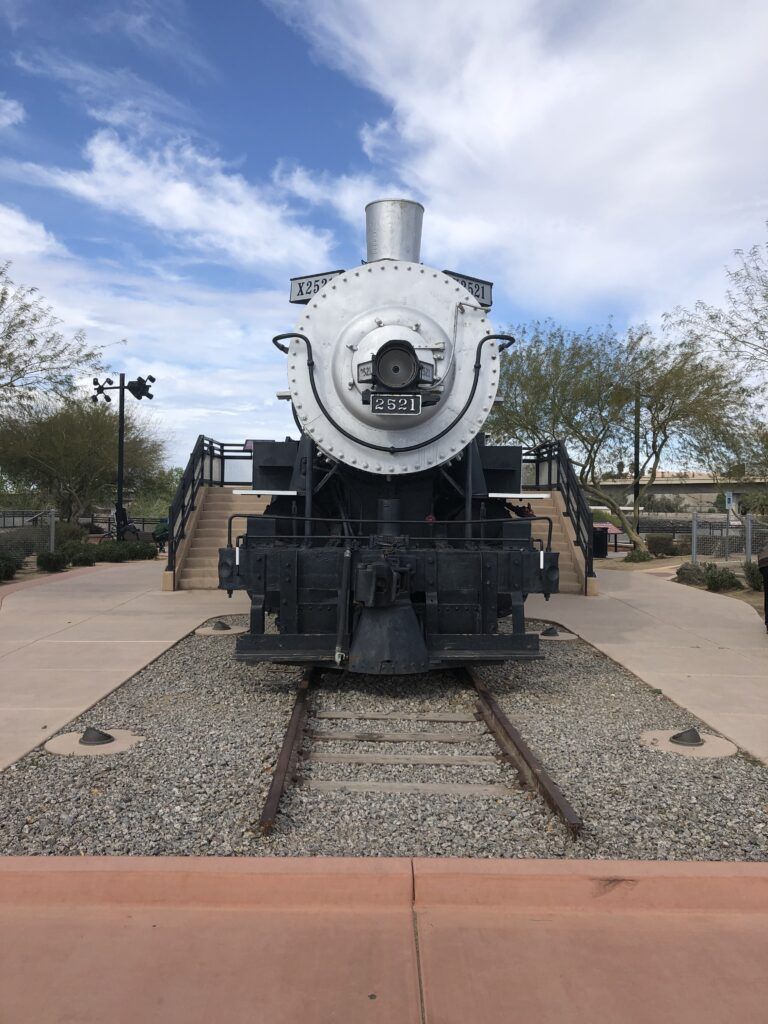
Location: North Madison Ave
City: Yuma
Region of State Located: Southwest Corner
Google Maps Pin
Located at the foot of Madison Avenue, Pivot Point Plaza is an outdoor interpretive park that marks the exact spot where the first railroad entered Arizona in 1877. The star of the show here is Steam Engine 2521, a massive Southern Pacific locomotive that stands as a silent monument to the days when the “Iron Horse” transformed the West.
The plaza gets its name from the “pivot point” of the original swing bridge that allowed riverboats to pass on the Colorado River while trains crossed above.
Great Photo Op: The locomotive is beautifully maintained and set against the backdrop of the river and the historic territorial prison nearby, making it a must-stop for history buffs and train enthusiasts alike..
A Massive Monument: The 2521 is a 2-8-0 “Consolidation” type steam locomotive. It’s an imposing piece of machinery that gives you a real sense of the scale and power required to haul freight across the grueling desert heat.
The Ghost Train: One of the coolest features of the plaza is the “Ghost Train” sound system. At scheduled times, you can hear the sounds of a vintage steam train pulling into the station, complete with the hiss of steam, the clanging bell, and the rhythmic chugging, creating a spooky, immersive atmosphere.
The Swing Bridge Pivot: You can still see the original concrete pivot pier in the park. In the late 1800s, this was a masterpiece of engineering, allowing the bridge to rotate 90 degrees to clear the path for tall steamboats.
Music Used in the Video: Lil’ Sunday Barbecue (Instrumental Version) by Jesse Lawrence– Licensed by Epidemic Sound
Stone Cabin
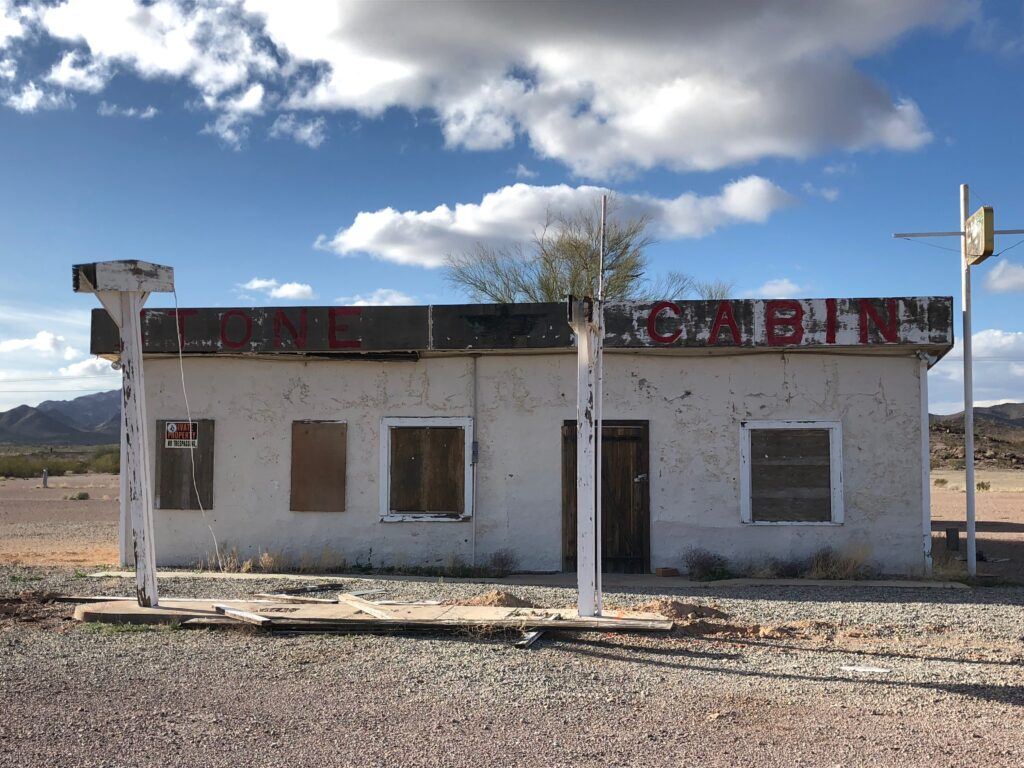
Location: US-95 Near Entrance To KOFA Wildlife Refuge
City: Yuma
Region of State Located: Southwest Corner
Google Maps Pin
Located near the entrance to the Kofa National Wildlife Refuge, the Stone Cabin is a rugged, historic structure that serves as a silent reminder of the early settlers and miners who braved the harsh Arizona desert. It sits along the road leading toward the famous Palm Canyon, making it a natural stop for those heading into the refuge.
The cabin is a primitive but fascinating piece of desert architecture that offers a glimpse into a much tougher era of Arizona history.
Pioneer Resilience: Built from local stone to blend into the landscape, the cabin was designed to provide essential shelter from the extreme heat and unpredictable desert weather.
Gateway to Kofa: Its position near the entrance makes it a great landmark for hikers and photographers who are about to explore the sprawling Kofa National Wildlife Refuge Click to open side panel for more information .
Photographic Contrast: The weathered textures of the stone walls against the backdrop of the jagged Kofa Mountains make it a favorite subject for desert photography, especially during the low light of sunrise or sunset.
A “Step Back” Experience: Unlike more commercialized stops, this is a quiet, remote site where you can truly appreciate the isolation and silence of the high desert.
Tank Display
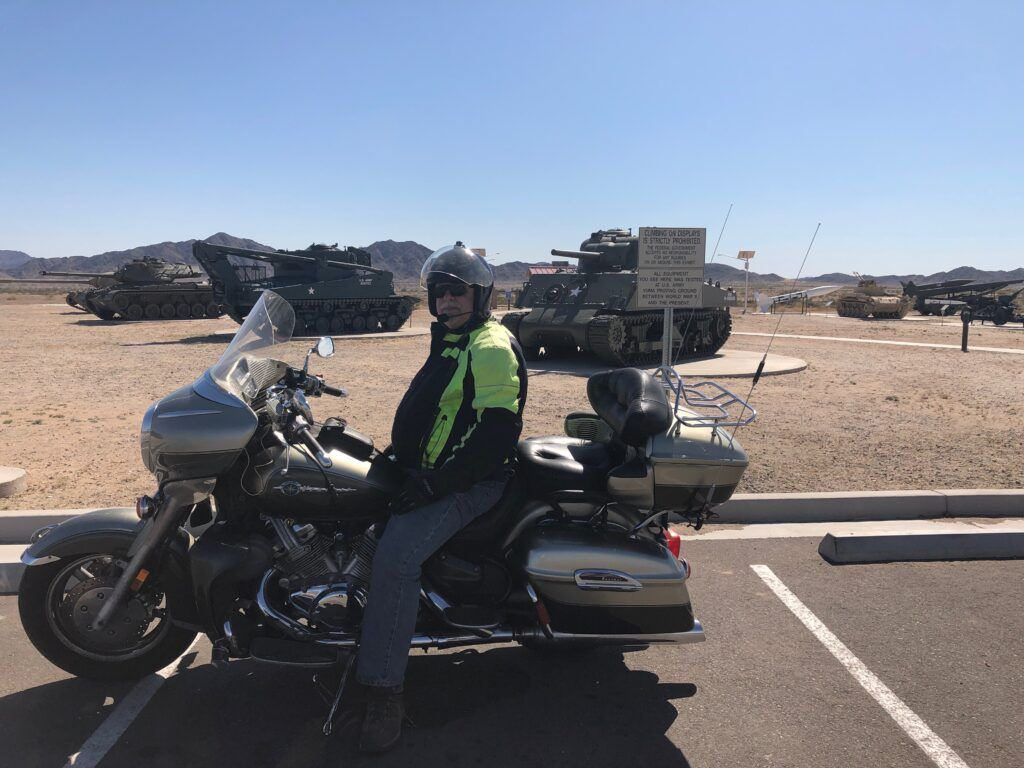
Location: Yuma Proving Grounds/ Visitor Control Center/ East Imperial Dam Rd
City: Yuma
Region of State Located: Southwest Corner
Google Maps Pin
Located just outside the Yuma Proving Ground Visitor Control Center, this impressive outdoor exhibit serves as a tribute to the heavy armor and artillery that has been tested in the Arizona desert for decades. The display features several retired military vehicles, most notably a massive main battle tank, mounted for public viewing.
It’s a striking sight that perfectly sets the tone for one of the largest military installations in the world.
First Impression: Positioned right at the entrance, it serves as a “gate guardian,” signaling to all who enter that they are stepping into a hub of modern military innovation and history.
Engineering Heritage: The tanks on display represent various eras of American armored warfare. They highlight the rigorous testing process that every vehicle must undergo at the Proving Ground to ensure it can survive extreme desert conditions.
Photo Opportunities: Because the display is located at the visitor center (which is outside the secure checkpoint), it is one of the few places on the installation where civilians can get up close to military hardware for photos.
Information Plaques: The site often includes informative markers that detail the specifications of the vehicles, their history in the U.S. Army, and the specific types of testing they underwent at Yuma.
The Seligman Depot
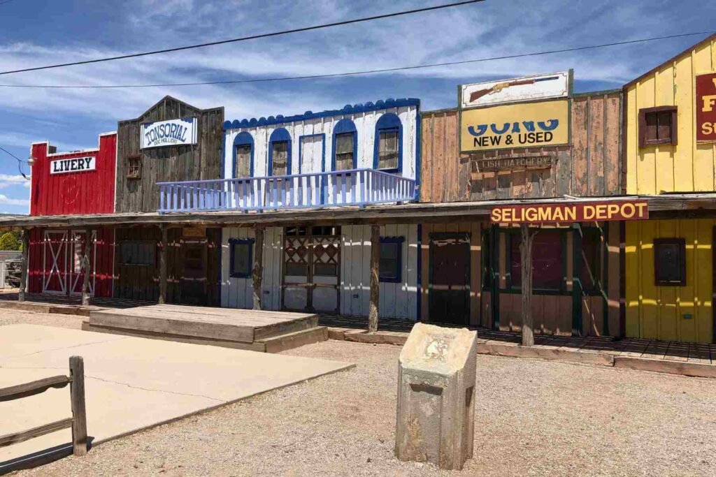
Location: 22830 W. AZ-66
City: Seligman
Region of State Located: Southwest Corner
Google Maps Pin
The Seligman Depot, a famous western town facade located at the western end of Seligman, Arizona.
While they look like authentic relics from the 1800s, these are actually decorative false-front storefronts built by the owners of the nearby Roadkill Cafe to attract tourists.
- The Storefronts: The facade typically includes five distinct storefronts designed to look like a frontier town: a Livery, a Tonsorial Parlor (barber shop/dentist), a hotel, a Gun Shop (“Guns New & Used”), and a Wells Fargo bank.
- “Tonsorial” Significance: The “Tonsorial” is a nod to Old West barber shops; it’s a fancy term for a place where you could get a haircut and a shave.
- The 1860 Arizona Territorial Jail: Just next to this display (often visible in the same area) is a small log cabin labeled as the “Jail,” which is another popular photo spot created by the same owners.
- Location: You’ll find it right on Historic Route 66, directly west of the Roadkill Cafe.
Tiny Church
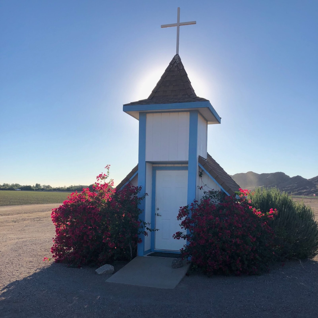
Location: US Highway 95, 5.5 miles north of Fortuna Rd
City: Yuma
Region of State Located: Southwest Corner
Google Maps Pin
Often referred to as the Tiny Church, Loren Pratt’s Little Chapel is a miniature sanctuary that stands as one of the most charming and unexpected stops along the Arizona desert highway. It was built as a memorial and a place of quiet reflection for travelers passing through the rugged Yuma landscape.
This pint-sized place of worship is meticulously maintained and remains open to anyone seeking a moment of peace.
Photography Favorite: Its diminutive size against the vast, open backdrop of the Arizona sky makes it an iconic subject for roadside photography.
Miniature Scale: The chapel is truly tiny, typically holding only a couple of people at a time. Despite its size, it features classic church architecture, including a small steeple and traditional wooden pews.
A Traveler’s Sanctuary: Inside, you’ll often find a guestbook filled with messages from people all over the world who have stopped to rest and reflect during their desert journeys.
The Story of Loren Pratt: It was built by a local man, Loren Pratt, who wanted to provide a spiritual roadside rest stop. It remains a beloved local landmark and a testament to individual faith and community spirit.
UFO Museum

Location: 12716 Alamo Rd
City: Yucca
Region of State Located: West Central
Google Maps Pin
Though often called the “UFO Museum” by travelers, this iconic site is officially known as Area 66. Located in the desert of Yucca, it features a massive, futuristic geodesic dome that looks like a grounded spacecraft.
It serves as a dedicated museum for all things extraterrestrial, blending local history with sci-fi intrigue.
Historical Context: Beyond the aliens, the museum often features displays about the local area’s history, including its ties to the nearby military testing ranges and old mining operations.
The Geodesic Dome: The centerpiece of the site is a large, white 40-foot dome. Originally built as a real estate office for a planned community that never quite materialized, it now perfectly fits the “Area 51” aesthetic.
Extraterrestrial Exhibits: Inside, you’ll find a quirky collection of UFO memorabilia, alien-themed displays, and “evidence” of sightings in the Arizona desert, which is a known hotspot for Ufology.
The “Desert Oddity” Vibe: Surrounded by scrap metal, vintage signs, and the vast open desert, the entire property has a kitschy, folk-art feel that makes it an essential photo stop for Route 66 and Highway 95 road-trippers.
Unfortunately, The day I was here the museum was closed.
Did you enjoy seeing Roadside Oddities & Attractions? Do you want to know when more are added? Consider subscribing. I only send update emails once a week, usually on Friday.