All Aboard the Cimarron Canyon Rail Exhibit: A Gravity-Defying Piece of Colorado History
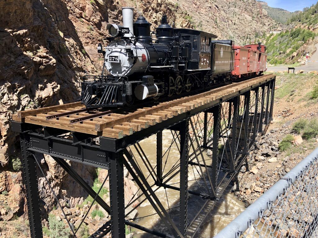
If you’ve ever wondered what it would be like to see a 69,000-pound steam locomotive casually sitting on a bridge over a roaring river, without the benefit of an active track beneath it, then have I got a Colorado roadside attraction for you. The Cimarron Canyon Rail Exhibit isn’t your typical museum piece gathering dust in a climate-controlled building. No sir, this beauty is perched dramatically on an 1895 trestle bridge, looking like it’s one strong wind away from making a spectacular splash into the Cimarron Creek below.
And the best part? Admission is absolutely free. Because nothing says “welcome to Colorado” quite like free access to death-defying railroad engineering.
Where in the World (or at Least Western Colorado)?
Located just above the town of Cimarron, about 20 miles east of Montrose, this outdoor display is part of the Curecanti National Recreation Area. You’ll find it tucked into the canyon about half a mile off the main highway on Morrow Point Dam Road, yes, the same road that leads to the impressive Morrow Point Dam.
The exhibit sits at the mouth of Cimarron Creek, just upstream from where it spills into the Gunnison River. There’s easy parking nearby, and if you’re feeling ambitious, you can take a well-paved walk up to the dam itself. The views of the canyon and river are absolutely spectacular, the kind that make you realize just how bonkers those railroad engineers must have been to think, “Yeah, let’s run a train through here.”
A Brief History of Madness (Also Known as the Denver & Rio Grande Railroad)
Back in the 1880s, the Denver & Rio Grande Railroad had big dreams and apparently very little concern for their engineers’ blood pressure. They wanted to connect Denver to the mining riches of western Colorado, and the only way to do that was to push their narrow-gauge line through the Black Canyon of the Gunnison, a canyon so steep and narrow that sunlight barely reaches the bottom even at high noon.
By August 1882, they’d accomplished what many thought impossible: blasting and carving a rail line through some of the most unforgiving terrain in North America. The company’s annual report that year noted that this stretch required “heavier work than on any other stretch of railroad in the country.” Translation: “This was absolutely insane, but we did it anyway.”
The route through the canyon was fifteen miles of pure heart-stopping drama. Famous British author Rudyard Kipling rode through in 1889 and wrote about entering “a gorge, remote from the sun, where the rocks were 2,000 feet sheer.” He described “a glory and a wonder and a mystery about that mad ride, which I felt keenly…until I had to offer prayers for the safety of the train.”
Apparently, praying became a regular pastime for passengers on what the railroad optimistically marketed as the “Scenic Line of the World.” The engineers who actually drove those trains through the canyon for the next 67 years were even less enthusiastic, especially during winter when avalanches and rockfalls kept everyone on edge. There’s scenic, and then there’s “I wonder if this will be the trip where we end up in the icy Gunnison River.”
Meet Locomotive #278: The Star of the Show
The centerpiece of the exhibit is Denver & Rio Grande Locomotive #278, a handsome steam engine built in 1882 by the Baldwin Locomotive Works in Philadelphia. This wasn’t just any locomotive, it was built specifically for the D&RG’s vast narrow-gauge network (those rails were just 36 inches apart, compared to the standard 56.5 inches).
Old #278 spent her working years serving the Crested Butte Branch and the Gunnison railyards, hauling coal, ore, passengers, and probably more than a few white-knuckled tourists. The locomotive has been lovingly restored to look as it would have in 1940, complete with its coal tender, a 1904 wooden boxcar, and an 1886 wooden caboose.
Here’s where it gets really interesting: this entire assemblage, all 69,000 pounds of the locomotive alone, plus the tender, boxcar, and caboose, sits atop a Pratt truss bridge that was originally constructed around 1895. This bridge is the last remaining piece of railroad infrastructure from the famous Black Canyon route, and in 1976, it earned a spot on the National Register of Historic Places. So yes, you’re looking at genuine American history here, not a replica.
How Did They Get a Locomotive Up There?
You might be wondering (as I certainly did) how exactly one goes about placing a 69,000-pound locomotive on a century-old trestle bridge spanning a creek. The answer involves a team from Winslow Crane, a 300-ton Terex-Demag crane, some serious engineering know-how, and probably a lot of crossed fingers.
After the locomotive and cars were restored, they were carefully rigged, lifted, swung into position, and set onto the historic trestle. It’s the kind of operation that makes you grateful you’re not in charge of the insurance paperwork. The precision required to place these heavy pieces of history back on their elevated perch is nothing short of remarkable.
The End of the Line (Literally)
The last train to run through the Black Canyon from Gunnison to Cimarron was a scenic excursion in 1949. By 1948, the railroad had already abandoned this portion of its famous route. The construction of Morrow Point Dam in the 1960s would eventually flood much of the original rail bed, making this exhibit and its trestle even more precious as historical artifacts.
The lease for the locomotive, tender, and caboose was renegotiated in 1989 and extended for 99 years, ensuring that future generations can marvel at this impressive display well into the 21st century. It’s a fitting tribute to the brave (some might say slightly unhinged) railroad workers who conquered one of the most challenging routes in American railroading history.
Why You Should Visit
The Cimarron Canyon Rail Exhibit is more than just a static display of old railroad equipment. It’s a portal into an era when human determination (and perhaps a healthy dose of foolhardiness) conquered seemingly impossible obstacles. Standing there, looking at that massive locomotive perched on its trestle with the creek rushing below, you can almost hear the hiss of steam and feel the rumble of wheels on narrow-gauge track.
The exhibit is perfect for photography enthusiasts, the contrast of the vintage train against the dramatic canyon backdrop is absolutely stunning. The area offers informative panels about the railroad’s history and the narrow-gauge trains that once dominated Colorado’s mountain railways. There are also displays about the local cattle and sheep ranching industry, complete with authentic cattle cars.
Best of all, it’s free, accessible, and you don’t need to be a railroad buff to appreciate it (though it certainly helps if you are). The short trails are easy to navigate, there’s plenty of parking, and it’s a perfect stop if you’re exploring the Curecanti National Recreation Area or making your way between Gunnison and Montrose.
Final Thoughts
In our age of high-speed rail and interstate highways, it’s easy to forget just how challenging, and dangerous, early railroad construction could be. The Cimarron Canyon Rail Exhibit serves as a powerful reminder of that pioneering spirit, preserved in steel and steam for all to see.
So the next time you’re traveling through western Colorado, take a short detour to visit this hidden gem. Stand beneath that massive locomotive on its elevated trestle, listen to the creek rushing below, and take a moment to appreciate the sheer audacity of those 19th-century railroad builders who looked at a vertical canyon wall and thought, “Perfect spot for some train tracks.”
Cost To Enter: $0
Pet Friendly: Yes
Always Check The Parks Official Website For Any Updates. You Can Use The Link Below.
Curecanti National Rec Area Official Website
Enjoy This Short Slideshow/Video of the Cimarron Canyon Rail Exhibit
Music Used in the Video: Road To Durango by Will Harrison & Traveling Home by Northside – Licensed via Epidemic Sound
Did you enjoy this post? Do you want to know when the next post comes out? Consider subscribing. I only send update emails once a week, usually on Friday. Try it out. You can unsubscribe at any time.
