
One of my absolute favorite things to do when I am out riding around is to find roadside oddities and attractions. I have been known to make many a U-turn while driving down the road. This page will be dedicated to any roadside attractions that I have found in the state of New York.
It will be a constant work in progress as I will add new oddities and attractions every time I find one. Make sure you check back often for new updates. Better yet, subscribe to my site so you will be informed each time content is added. Don’t worry, no spam here. I only send out emails once a week, usually on Fridays. Subscribe Here
Bannerman Castle
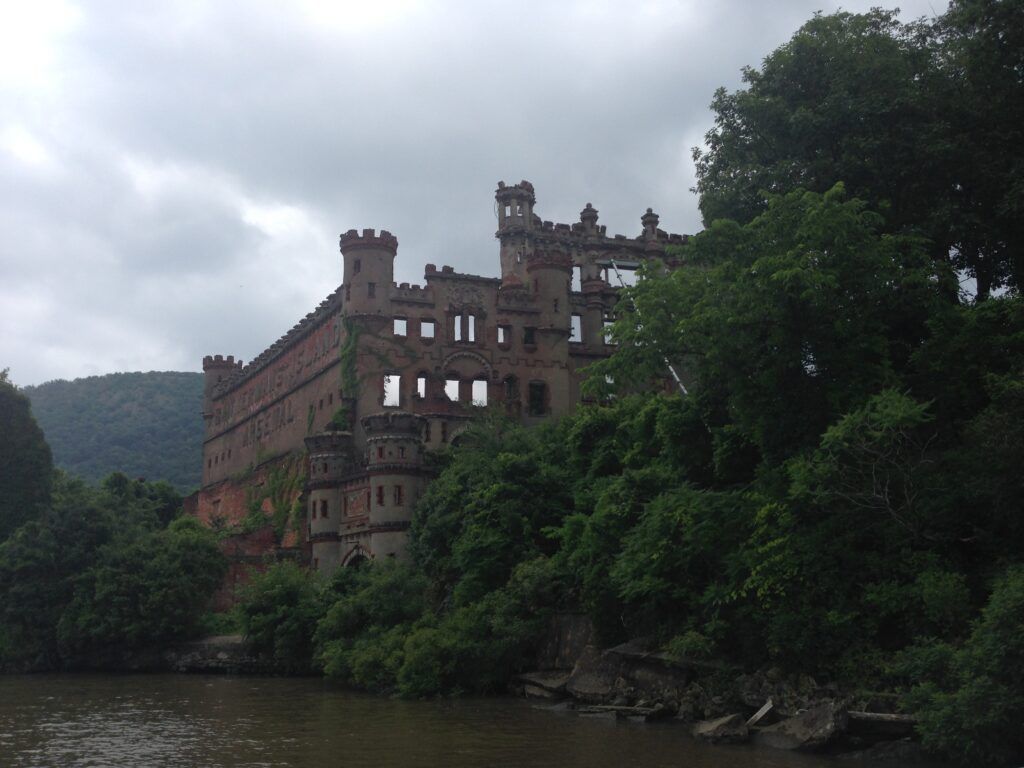
Location: Bannerman Island
City: Beacon
Region of State Located In: Southern
Google Maps Pin
Located on Pollepel Island in the middle of the Hudson River, Bannerman Castle is a massive, crumbling fortress that looks like it was plucked straight from the Scottish Highlands and dropped into the Hudson Valley.
Though it looks like a medieval relic, it has a much more “explosive” American history.
The Summer Residence: In addition to the massive arsenal, there is a smaller, more ornate “residential castle” on the island where the family spent their summers surrounded by beautiful (and now restored) gardens.
A Surplus Super-Warehouse: Built starting in 1901 by Francis Bannerman VI, the castle wasn’t a residence for royalty, but a giant warehouse for his massive military surplus business. He bought so much Spanish-American War ammunition that New York City forced him to find storage outside city limits for safety.
The “Bannerman’s Island Arsenal” Sign: As you approach by boat, you can still see the giant letters cast into the castle wall. It was essentially a massive, stone-and-brick billboard for his business that could be seen from the shore and passing trains.
A History of Disasters: The castle’s “ruined” look is the result of a series of unfortunate events, including a massive 2020 powder explosion that sent a chunk of the building into the family’s hammock, and a devastating 1969 fire that gutted the remains.
Accessing the Island: Since it’s in the middle of the river, it’s only accessible by boat or kayak. Most people take the Estuary Steward from Beacon, NY. Be prepared for a bit of a workout, there are 72 steps to climb from the dock to reach the historic trails.
Music Used in the Video: Sweet Taste (Instrumental Version) by Flux Vortex- Licensed via Epidemic Sound
Grumman Park
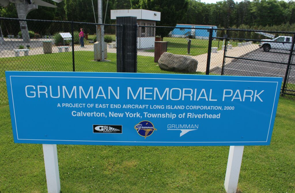
Location: 4670 NY-25
City: Calverton
Region of State Located In: Eastern Long Island
Google Maps Pin
Located on the hallowed grounds where some of the world’s most iconic aircraft were once built and tested, Grumman Memorial Park serves as a powerful tribute to Long Island’s “Cradle of Aviation” history. Situated on the site of the former Grumman Naval Weapons Industrial Reserve Plant, the park is a must-visit for aerospace enthusiasts.
It’s an open-air museum that captures the engineering might of the Cold War era.
Commemorative Bricks: The plaza is lined with thousands of engraved bricks, many placed by former Grumman employees (“Grummanites”) and their families, making the site feel more like a community shrine than just a hardware display.
The “Tomcat” Centerpiece: The star of the park is the F-14A Tomcat, the legendary swing-wing fighter made world-famous by Top Gun. This specific aircraft (BuNo 160382) was actually a testbed for various engines right there at the Calverton facility.
The A-6E Intruder: Standing alongside the Tomcat is an A-6E Intruder, the rugged, all-weather attack aircraft that was the workhorse of the Navy’s carrier wings for decades, also a product of Grumman’s Long Island plants.
Lunar Legacy: The park features a dedicated “Moon Walk” memorial, honoring Grumman’s role in building the Lunar Module (LM) that landed astronauts on the moon. It’s a proud reminder that the vehicle that touched the lunar surface was “made on Long Island.”
Horton Point Lighthouse
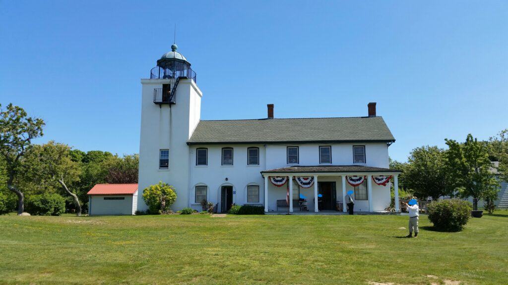
Location: 3575 Lighthouse Rd
City: Southhold
Region of State Located In: North/East Long Island
Google Maps Pin
Commissioned by George Washington in 1790 and finally constructed in 1857, the Horton Point Lighthouse Click to open side panel for more information stands as a sentinel over the Long Island Sound. This historic tower is one of the most picturesque maritime landmarks on the North Fork, offering a blend of nautical history and stunning coastal scenery.
The site is much more than just a lighthouse; it’s a community park and museum that captures the essence of Southold’s seafaring past.
Architectural Detail: The tower itself is built of square-cut granite and stands 58 feet tall. Its classic design makes it a favorite subject for artists and photographers capturing the North Fork landscape.
Commanding Views: Perched on a 60-foot bluff, the lighthouse provides panoramic views of the Long Island Sound. On clear days, you can see all the way across the water to the Connecticut shoreline.
Nautical Museum: The Keeper’s House has been converted into a museum filled with maritime artifacts, photographs, and historical exhibits detailing the lives of the lightkeepers and the shipwrecks that occurred nearby.
Scenic Grounds: The surrounding park features picnic areas and a “nature trail” that leads down a wooden staircase to the rocky beach below, which is a popular spot for beachcombing and photography.
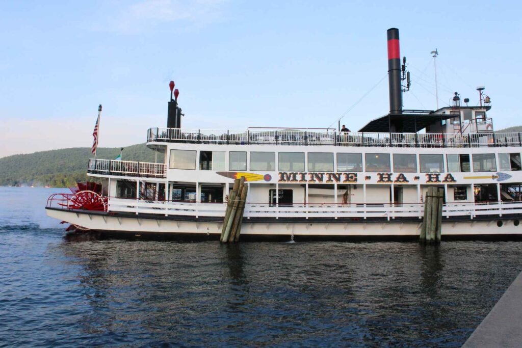
Minne Ha-Ha
Location: 57 Beach Road
City: Lake George
Region of State Located In: North/East
Google Maps Pin
A true icon of the Adirondacks! The Minne-Ha-Ha is one of the last authentic steam-powered paddlewheelers in America. Operating as part of the Lake George Steamboat Company, this colorful red, white, and blue vessel has been a staple of the “Queen of American Lakes” since 1969.
- Authentic Steam Power: Unlike many modern “replicas” that use diesel engines, the Minne-Ha-Ha is powered by a genuine steam engine. You can actually look down into the engine room from the deck to see the massive pistons turning the paddlewheel.
- The Calliope Concert: One of the boat’s most famous features is its steam calliope (a musical instrument played with steam-whistles). As the boat pulls away from the pier in Lake George Village, the cheerful, high-pitched music can be heard echoing across the water for miles.
- Photographer’s View: If you want to grab a great picture, the best shots are often from the shoreline as she makes her turn back toward the docks. The bright red paddlewheel churning up white water against the deep blue of the lake and the green mountains is a classic “Upstate New York” composition.
- A Living Legend: While the Lake George Steamboat Company dates back to 1817, the Minne-Ha-Ha (named after the fictional Native American woman from Longfellow’s The Song of Hiawatha) represents the whimsical, mid-century era of lake tourism.
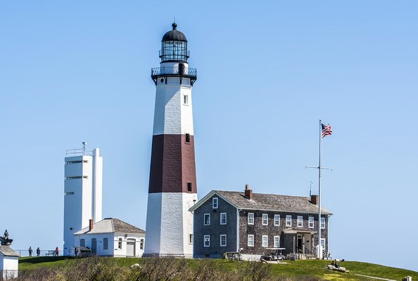
Montauk Point Lighthouse
Location: 2000 Montauk Highway
City: Montauk
Region of State Located In: South/East Tip Long Island
Google Maps Pin
A true crown jewel of New York landmarks, the Montauk Point Lighthouse sits at the extreme eastern tip of Long Island, a spot affectionately known as “The End.” It was the first lighthouse built in New York State and is the fourth oldest active lighthouse in the United States.
It’s not just a navigational aid; it’s a National Historic Landmark that represents the very edge of the Empire State.
World-Class Surf Fishing: The waters surrounding the lighthouse are legendary among anglers; Montauk is often called the “Surf Fishing Capital of the World,” particularly during the fall “striper” run.
A Gift from Washington: In 1792, President George Washington authorized the construction of the lighthouse to protect the busy shipping lanes heading toward New York City.
Climb to the Top: For those with the stamina, the 137 iron steps to the top of the tower offer a breathtaking, 360-degree view of the Atlantic Ocean and Block Island Sound.
The “Lost at Sea” Memorial: The grounds feature a moving memorial dedicated to the many fishermen and sailors who never returned home, underscoring the raw power of the ocean at this point.
Battling the Elements: One of the most fascinating aspects of the site is the massive stone revetment (sea wall) built to prevent the lighthouse from falling into the ocean due to the extreme erosion of the Montauk bluffs.
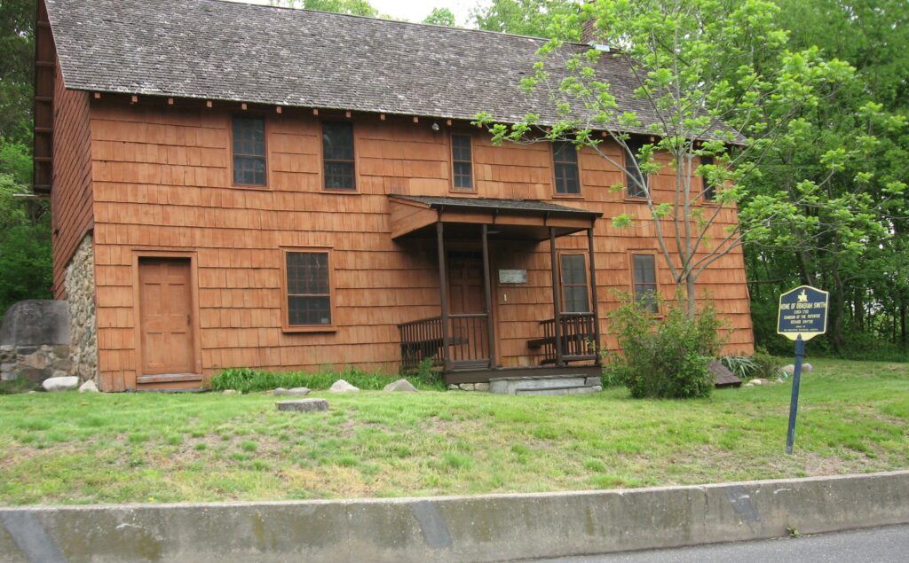
Obadiah Smith House
Location: 853 St Johnland Rd
City: San Remo
Region of State Located In: North/Central Long Island
Google Maps Pin
Located in the San Remo neighborhood of Kings Park, the Obadiah Smith House is a rare surviving example of early 18th-century architecture on Long Island. Built around 1740, this weathered saltbox-style home serves as a quiet time capsule, preserving the history of one of Smithtown’s founding families.
It is a stark contrast to the modern suburban sprawl surrounding it, standing as a humble reminder of Long Island’s colonial roots.
Restoration Efforts: Now owned by the Smithtown Historical Society, the house has undergone extensive restoration to save it from the elements, ensuring that this 280-plus-year-old structure remains a focal point for local history.
Architectural Longevity: The house features the classic “saltbox” roofline and heavy timber framing characteristic of early English colonial construction. Much of its original interior, including the massive central fireplace and wide-plank floors, remains remarkably intact.
The Smith Family Legacy: Obadiah Smith was the grandson of Richard “Bull” Smith, the legendary founder of Smithtown. The house stayed in the Smith family for generations, which helped preserve its historical character.
A Revolutionary History: During the American Revolution, the house sat in a region occupied by British forces. Local legend suggests the house, and the Smiths themselves, had to navigate the dangerous tensions between Loyalists and Patriots on the North Shore.
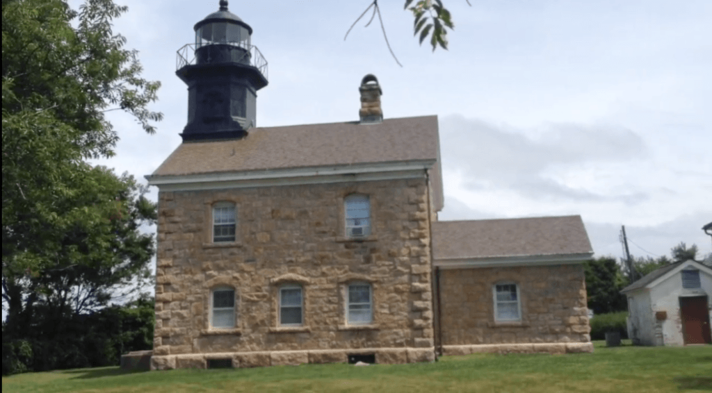
Old Field Lighthouse
Location: 207 Old Field Rd
City: Setauket-East Setauket
Region of State Located In: North/Central Long Island
Google Maps Pin
Perched on the northernmost tip of a narrow peninsula, the Old Field Point Lighthouse is a striking example of Victorian-era Gothic architecture. Completed in 1868, this granite tower and connected keeper’s house overlook the treacherous “Old Field Rip,” where the waters of the Long Island Sound and Smithtown Bay collide.
It is often cited as one of the most elegant lighthouses on the East Coast due to its ornate stonework and unique design.
Scenic Isolation: Located at the end of a quiet residential road, the lighthouse grounds offer a peaceful, windswept atmosphere with views of the Connecticut shoreline roughly 15 miles across the water.
Twin of Fire Island: The lighthouse was built using the same architectural plans as the Plum Island and Block Island North lights, featuring a distinctive square tower attached directly to the two-story residence.
Strategic Vantage Point: During the Revolutionary War, this point was used by lookouts to track British ship movements in the Sound. Later, the 1868 stone tower replaced a smaller, 1823 wooden version that wasn’t quite tall enough to be seen from the necessary distance.
Modern Protection: Today, while the original Fresnel lens is long gone, the light remains an active aid to navigation. The site is also home to a high-tech Coast Guard communication tower, blending 19th-century history with modern maritime safety.
Painted Pony Rodeo

Location: 703 Howe Rd
City: Lake Luzerne
Region of State Located: North/East
Google Maps Pin
Located just a few miles south of Lake George in the Adirondack foothills, the Painted Pony Championship Rodeo is a high-energy slice of Western culture in the heart of Upstate New York. Established in 1953, it is the oldest weekly championship rodeo in the United States, offering a rugged and authentic experience that feels like it was transported straight from the Texas plains.
- Professional Action: As a sanctioned PRCA event, the rodeo features top-tier athletes competing in heart-pounding events like bull riding, bareback bronc riding, steer wrestling, and barrel racing.
- The Full Cowboy Experience: For the ultimate night out, you can purchase a combo ticket that includes both the rodeo performance and a Texas-style BBQ buffet. It’s a great way to fuel up on ribs, chicken, and all the fixings before the dust starts flying in the arena.
- Nostalgic Atmosphere: The venue maintains a classic, mid-century roadside appeal, offering a family-friendly environment that has remained largely unchanged for generations.
Perkins Tower
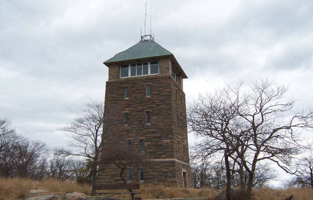
Location: Perkins Memorial Drive
City: Stony Point
Region of State Located: South/East
Google Maps Pin
Located at the summit of Bear Mountain, Perkins Memorial Tower is a 40-foot stone observatory that offers some of the most spectacular 360-degree views in the Hudson Valley. Built in 1934 by the Civilian Conservation Corps (CCC), it was dedicated to George W. Perkins, the first president of the Palisades Interstate Park Commission.
At an elevation of 1,305 feet, it serves as a high-altitude highlight for travelers on the scenic Seven Lakes Drive.
CCC Craftsmanship: Like many structures in the park, the tower is built from local granite and timber, reflecting the “National Park Service Rustic” style that was designed to blend seamlessly with the natural landscape.
Spectacular Reach: On a clear day, you can see four states (New York, New Jersey, Connecticut, and Pennsylvania) as well as the Manhattan skyline shimmering on the horizon, nearly 40 miles to the south.
A Historical Museum: The base of the tower features several floors of museum-style displays, including vintage photographs and tiles that explain the history of the park, the local ecology, and the construction of the tower itself.
The “Bear Mountain” Hub: The tower is a key landmark along the Appalachian Trail, which passes right through the park. It’s a popular spot for hikers to stop, catch their breath, and soak in the views of the Bear Mountain Bridge and the Hudson River winding below.
The Big Duck
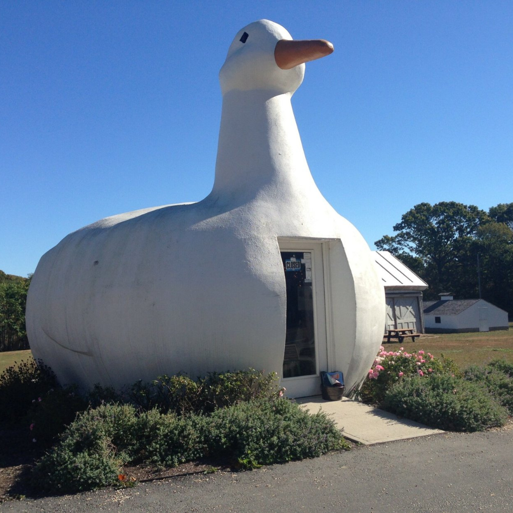
Location: 1012 NY-24
City: Flanders
Region of State Located: East/Central Long Island
Google Maps Pin
A true icon of American roadside architecture, The Big Duck in Flanders is perhaps the most famous example of “Programmatic Architecture” in the world. In fact, this 20-foot-tall, 30-foot-long bird is so influential that architects actually use the term “Duck” to describe any building that is shaped specifically like the product it sells.
Holiday Tradition: Every year, the community holds an annual “Duck Lighting” ceremony for the holidays, complete with caroling and the duck being draped in a massive festive wreath.
A Poultry Pedigree: It was originally built in 1931 by duck farmer Martin Maurer in Upper Riverhead as a shop to sell his Peking ducks and eggs. He was inspired by a coffee-pot-shaped building he saw while traveling in California.
The Design: The duck is made of concrete over a wooden frame, and it famously features two Ford Model T tail lights for eyes, which glow red at night.
A National Treasure: It is listed on the National Register of Historic Places. While it has moved a few times over the decades (it’s a traveling duck!), it returned to its “Big Duck Ranch” home in Flanders in 2007.
The Jones Beach Water Tower
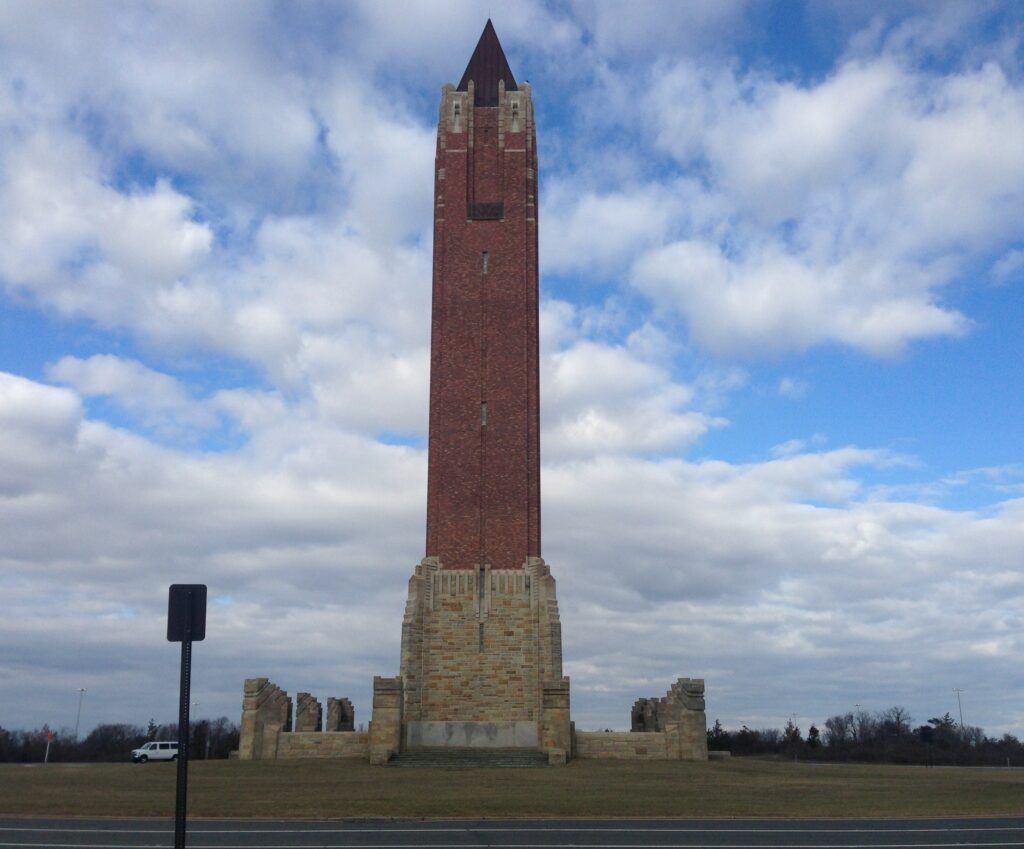
Location: Wantagh Parkway & Ocean Parkway
City: Wantagh
Region of State Located: South/West Long Island
Google Maps Pin
Often called “The Needle” or “The Pencil,” the Jones Beach Water Tower is a 188-foot-tall masterpiece of Italian Renaissance-inspired architecture. Standing at the center of a massive traffic circle at the entrance to Jones Beach State Park, it serves as both a functional water reservoir and an unmistakable gateway to the Atlantic coast.
It was designed in the late 1920s under the direction of Robert Moses, who insisted that even a utility structure should be a work of art.
Hurricane-Tested: Despite its slender appearance and exposed location on a barrier island, the tower has survived every major storm since 1930, including the devastating Hurricane Sandy, thanks to its deep foundations and solid masonry construction.
Inspired by Venice: The tower was modeled after the famous St. Mark’s Campanile in Venice, Italy. It is constructed from orange Ohio sandstone and dark red Barbary brick to ensure it stood out against the coastal sky.
Hidden Utility: While it looks like a purely decorative monument or a bell tower, it actually contains a 315,000-gallon steel water tank that provides fresh water for the entire park’s bathhouses and facilities.
A Precision Landmark: It sits perfectly at the intersection of the Wantagh and Ocean Parkways. For generations of New Yorkers, catching the first glimpse of “The Needle” on the horizon is the official sign that the beach day has begun.
Uncle Sam
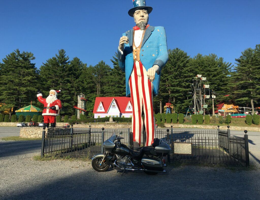
Location: 1912 US-9
City: Lake George
Region of State Located: Eastern
Google Maps Pin
Standing 38 feet tall in the parking lot of the former Magic Forest (now Lake George Expedition Park), the Uncle Sam statue is a classic “Muffler Man” variant that has become a beloved landmark for anyone traveling through the Adirondacks.
It is widely considered to be the world’s tallest Uncle Sam and is a prime example of mid-century fiberglass roadside giants.
A Local Legend: For decades, he stood alongside other quirky statues like the “Jack and the Beanstalk” figure, but Uncle Sam’s sheer height and patriotic flair made him the undisputed king of the lot.
A Paul Bunyan Makeover: Like many of the giants you’ve tracked, this figure was originally cast by International Fiberglass as a “Paul Bunyan” model. In the 1960s, it was modified with a top hat, a goatee, and a red-white-and-blue paint job to transform him into the iconic national figure.
Danbury Roots: Before he moved to Lake George, this massive Sam spent years standing outside a tool and die shop in Danbury, Connecticut. He was eventually purchased by Arthur Gillette, the founder of Magic Forest, who brought him to New York to greet park guests.
Survival of the Park: While the original Magic Forest has evolved into the dinosaur-themed Lake George Expedition Park, Uncle Sam remains a permanent fixture, still standing tall in the parking lot even as other attractions have changed around him.
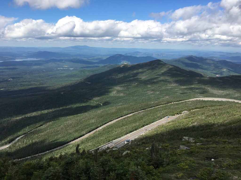
Whiteface Mountain
Location: Veterans Memorial Highway
City: Wilmington
Region of State Located: North/East
Google Maps Pin
Not only is Whiteface Mountain a great ski area, you can also drive to the top in the summer months (elevation of 4867 feet), weather permitting. Whiteface Mountain is the 5th highest peak in elevation in New York. Once at the top you will walk through a tunnel and start walking on the trails. The walking trails are rocky and some are steep but there are handrails. The views are amazing. There are restrooms at the top. The only negative here is the entry fees are steep at around $20.
Official Webpage for Veterans Memorial Highway/Whiteface Mountain
Music in this Video: Rock Haze by The Big Let Down – Licensed via Epidemic Sound
Did you enjoy seeing Roadside Oddities & Attractions? Do you want to know when more are added? Consider subscribing. I only send update emails once a week, usually on Friday.